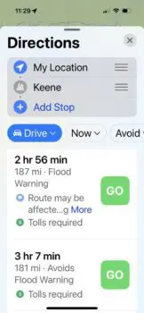
I was ready to hit the road home. The rains had stopped, and it looked like smooth sailing across New Hampshire and Maine. Until…I punched in my destination on my Maps app. Four out of five possible routes had flood warnings. Deciding not to chance being turned back half way home, I took the one that was clear. I saw parts of New Hampshire I had never seen. Luckily it’s a beautiful state so the extra time quickly passed as I wound around lakes and hills.
Warning the driver of potential hazards ahead is just one of the many cool features of the Maps App. Here are seven more.

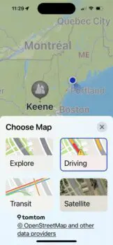
Multiple options for the type of map you need:
 Explore
Driving
Transit,
Satellite
Choose the type of map you want by tapping wavy icon in the top right corner. See arrow on the image below.

Explore
This feature allows you to see what types of businesses, historical sites, and recreational facilities are in the area. By using your fingers to expand the screen, you will see more detail.

Driving
This version of the area you have chosen shows all of the roads. Plus you can see construction work (red lines) and other possible obstacles.

Transit
With this map, you can find subway, train, and bus routes. The dots along the lines indicate stops. As a kid, I used to take the MTA’s Red Line into Boston. Never did meet Charlie who was riding forever.

Satellite
This map gives you a bird’s eye view of the area.

You can see your choice of routes by tapping on the blue box with the car icon on it. Look at the image above to see what that button looks like.
Once you tap the button, more options appear. This screen allows you to make some choices.


2. Also, by tapping Avoid, you can choose routes that stay away from toll roads and highways. Personally, I love back country roads so this option stays on almost all of the time.

3. Perhaps you are not traveling by car. Notice on the blue box that says Drive that there is a downward pointing arrow. Tap there and you will see your other options that include walking, cycling, and ride shares.

Did you know that your Apple Maps app also shows the interior of major airports. This feature helps you locate your gate, rest rooms. and restaurants. Here are a couple of images that show Terminal A at Logan Airport in Boston.

Terminal A

Facilities

Lastly, I often have my Maps on even when I know my route because it keeps track of the speed limit and my estimated time of arrival. Both good things to know.
Wishing you many happy adventures this spring and summer! If you are not a Mainer, consider visiting the Pine Tree State. Just tap in Harpswell, Maine in your Maps app and come on up for some lobster!

If you are traveling in the future, be sure to download our Digital Device Travel Checklist to make sure you do not leave any vital piece of equipment home.
Notifications